|
All
About Boundary Surveys
A boundary survey is a professional
surveyor’s opinion as to the locations of your property
lines, based on your deed and other available title information.
Boundary determinations are based on long established and accepted
principles. We prefer that our clients provide us with a copy
of their title insurance policy or pay a title company to provide
a preliminary title report containing a title insurable legal
description of your property.
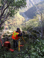
A boundary survey begins with a preliminary
field survey, during which a
field crew using a theodolite (transit) and electronic distance
measurement, takes accurate measurements to property corner markers
that are found on or near the property being surveyed. Global
Positioning Systems are sometimes used on large properties with
limited tree cover.
The preliminary field survey information
is then analyzed, with the standard boundary principles being
applied, to determine the boundary location. The survey crew
then returns to the property to set monuments or markers wherever
they are needed. Typically, we don’t provide line stakes
or other points along the property lines themselves, unless you
make arrangements for this additional work.
Finally, State law requires that a
record-of-survey map be prepared to document the work, whenever
we set markers that have never been established on a prior recorded
survey, or whenever we find discrepancies with prior record information.
The law also requires that we pay a fee to the County Surveyor
to check the map to assure that it meets certain technical requirements.
After the County Surveyor checks the map, it is filed with the
County Recorder and it becomes a perpetual record of the survey
work. The County Surveyor’s check seldom results in any
changes in the boundary locations. However, all map prints are
stamped preliminary, and are subject to change, up until the
time that they are recorded. The County Surveyor is allowed about
30 days to complete his map check.
We typically set 18" long 3/4" diameter
water pipe for corner monuments or markers. They are tagged with
the surveyor’s license number. We set the markers with about
4" of the pipe above the ground so that they can be found
later. When set, we place wooden guard stakes by the pipe monuments
to help you find them initially. We can also guard them with
steel fence posts, if you wish. Fence posts are particularly
useful in rural areas, when corner monuments can be difficult
to find at a later date.
We are sometimes asked if a survey
can be challenged. Keeping in mind that a boundary survey represents
our professional opinion, it is possible that another surveyor,
perhaps based on new or additional evidence could arrive at a
different opinion. This occurrence is fairly rare. If a question
arises at any time following our field survey, we will work with
any other surveyor in an effort to agree on the proper boundary
interpretation.
|